Applications
Subduction zone scenarios
Megathrusts host one of the biggest earthquakes worldwide, such as the 1960 Great Chiliean Earthquake, the 2004 Sumatra-Andaman Earthquake and the 2011 Tohoku earthquakes. Most of these events are followed by devastating tsunamis.
We use dynamic rupture simulations to increase our understanding of the earthquake source characteristics leading to tsunamis.
From a computational point of view these scenarios are particular challenging: Due to the intersection of the low dipping subduction fault with topography and bathymetry as well as the subsurface structure, many small discretizations elements are generated during the automatic mesh process.
These small elements require small time steps in order to fulfill stability conditions which quickly leads to a large increase in computational time.
In order to deal with these kind of geometries, we recently incorporated local time-stepping for the whole simulation process, including the dynamic rupture part of the software, tremendously shortening time-to-solution (Breuer et al. 2014, Uphoff et al. 2017).
The 2004 Sumatra-Andaman Earthquake
A specifically devastating megathrust earthquake is the Mw 9.1 2004 Sumatra-Andaman Earthquake and Indian Ocean Tsunami. The Sumatra earthquake ruptured the greatest fault length of any recorded earthquake and triggered a series of tsunamis, killing up to 280,000 people in 14 countries.
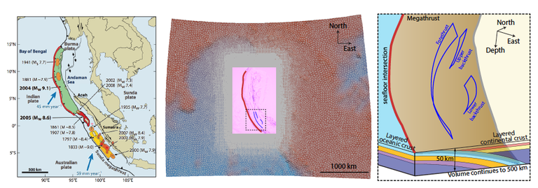
To gain insight into the earthquake source processes that lead to this tsunami we conducted the very first dynamic rupture scenario of the 2004 Sumatra earthquake. We resolve the full frictional sliding process in a complex fault network as well as the seismic wave field with frequency content up to 2.2 Hz in the to-date longest (500 s) and largest (1500 km) physics-based earthquake simulation.
Simulation results
The large- scale, high-resolution scenario is compared against geodetic, seismological and tsunami observations. The comparison with available GPS data (yellow) shows that our simulation results (green) fit quite well.
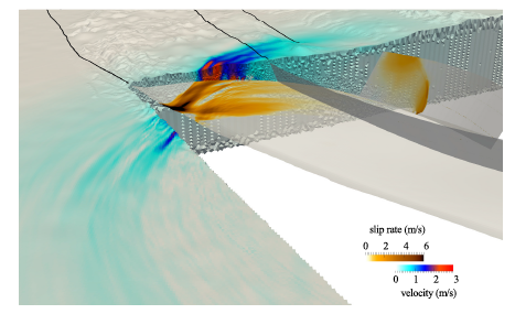
The output of the simulations is analyzed in terms of fault mechanical properties such as slip rate and total slip on the fault.
The modeled high-resolution seafloor displacement will serve as spatio-temporal input in tsunami simulations to study tsunami generation and propagation.
For the future we plan detailed parameter studies to understand the conditions under which a megathrust earthquake can efficiently generate tsunamis.
This scenario and its optimization is fully described in the SC17 paper "Extreme scale multi-physics simulations of the tsunamigenic 2004 sumatra megathrust earthquake" by C.Uphoff, S. Rettenberger, M. Bader, E. H. Madden, T. Ulrich, S. Wollherr und A.-A. Gabriel (Proceedings of the International Conference for High Performance Computing, Networking, Storage and Analysis, November 2017. Finalist for Best Paper Award.)
Press release of the Gauss Centre for Supercomputing.
Strike-slip scenarios
1992 Landers earthquake
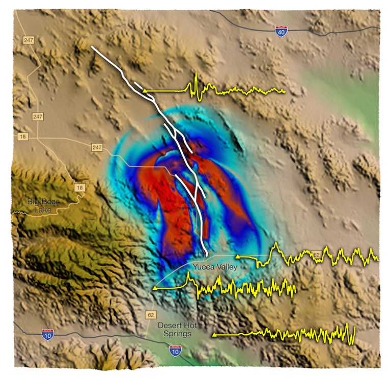
The non-linear interaction of the seismic waves with the fault system itself and the spatio-temporally heterogeneous rupture process add further complexity, causing the emergence of multiple rupture fronts.
The resolution in a model consisting in almost 200 mio. elements leads to accelerograms with frequencies up to 10 Hz.
In this high-resolution earthquake model complex rupture
dynamics evolve across the fault system .
Successively, all fault segments of the model rupture spontaneously. Throughout the rupture process we observe fault branching as well as rupture jumps between the discrete fault planes, leaving some segments partially locked.
(for more details, especially from a computational perspective, see:
Heinecke et al. , Petascale High Order Dynamic Rupture Earthquake Simulations on Heterogeneous Supercomputers. (2014). Gordon Bell Finalist. doi:10.1109/SC.2014.6 )
We simulated the Mw. 7.3 Landers scenario on a branched fault system in a model including geologically constrained fault geometries, topography, the local velocity structure and stress conditions based on geomechanical modeling.
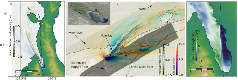
2018 Palu, Sulawesi Earthquake and Tsunami
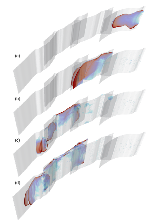
The figure below illustrates a 3D fully coupled model of the tsunami caused by the magnitude 7.5 strike-slip supershear earthquake that struck Palu Bay of the island of Sulawesi, Indonesia, on September 28, 2018. Tsunamis occur due to abrupt vertical perturbations to the water column. Devastating tsunamis are therefore rarely caused by strike-slip earthquakes (such as the Sulawesi earthquake), as these produce predominantly horizontal displacements. What was additionally unusual about the Sulawesi earthquake was its ability to produce very fast (“supershear”) movements during the rupture itself. This surprising earthquake-tsunami behavior has led to an extensive debate with important implications for submarine strike-slip fault systems worldwide.
Húsavík-Flatey transform fault zone in North Iceland
The ~100 km long Húsavík Flatey Fault Zone (HFFZ) in North Iceland is the largest linear transform fault zone in Iceland composed of multiple fault segments that localise both strike-slip and normal movements, agreeing with a transtensional deformation pattern (Garcia and Dhont, 2005). With maximum seismogenic potential larger than Mw 7 (Metzger and Jónsson, 2014) and located primarily offshore, the HFFZ subjects several nearby coastal communities to potentially significant tsunami hazard from strong earthquake occurrence on the HFFZ. Namely, tsunami hazard assessment of submarine strike-slip fault systems in transtensional tectonic settings worldwide has received increased attention since the unexpected and devastating local tsunami in the Palu Bay following the 2018 Mw 7.5 Sulawesi earthquake in Indonesia.
